Do you know Google Earth Pro that can check the map in 3D? It can be installed for free on a PC, and if there is data in the area, you can enjoy past aerial photographs and virtually experience the desired location. This time, I will introduce the basic usage of such Google Earth Pro.
Please enjoy the nostalgic streets and scenery that you used to live in.
How to use Google Earth Pro on your PC? Download first!
To use Google Earth Pro on your PC, install the software first. Free delivery for Windows, Mac or Linux.
* The device used for this explanation is HUAWEI Matebook X (Windows 10).
[Reference] Google Earth Pro
After accessing the reference link above, read the terms of use carefully and click "Agree and download". The download of Google Earth Pro will start.
When the download is complete, open the file and follow the instructions to install it. When setup is complete, you should see the Google Earth Pro icon on your desktop as shown below.
The above is how to install the Windows version. Follow the steps below to install Google Earth Pro for Mac.
1: Open "Google EarthProMac-Intel.dmg". 2: Open the "Install Google Earth Pro.pkg" file and follow the instructions to install. 3: Double-click "Google Earth Pro". After successfully installing Google Earth Pro, let's check how to actually use it.
[Reference] Installing and uninstalling Google Earth Pro
Google Earth Pro is free software, but you can also enjoy "Google Earth" on your browser (WEB).
However, some functions cannot be used with Google Earth (WEB).

For example, with Google Earth Pro, you can check satellite images of Mars and display the position of the sun in addition to the earth. There are various other functions in Google Earth Pro, but if you want to check the usability before installation, you can enjoy Google Earth on your browser (WEB) first.
When you start Google Earth Pro, you will see a screen like the one in the picture above. Google Earth Pro is versatile and has various buttons on the screen, which may seem complicated at first. However, once you get used to the operation, it is easy to use.
This time, we will introduce the basic usage, not the abundant functions of Google Earth Pro, so please refer to it.
First, let's move the displayed globe. You can rotate the globe in any direction by clicking and moving the mouse left, right, up and down.
After moving the globe, try rotating the mouse wheel. Then you can enlarge / reduce the map. You can also operate using the arrow keys on the keyboard or the icon displayed in the upper right of the screen (see the photo above).
Then finally the main subject! Let's enjoy the past aerial photograph data with Google Earth Pro.
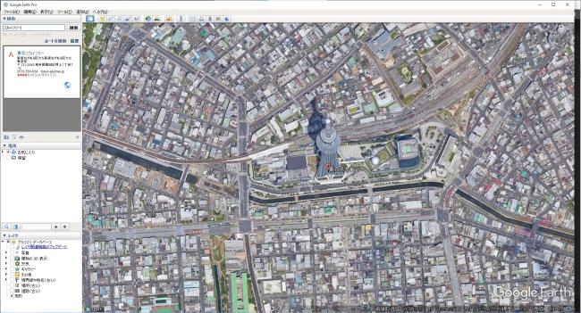
First, start Google Earth Pro and display the area where you want to check past aerial photographs. This time, as an example, I will check the photos near "Tokyo Sky Tree".
After displaying the destination, click the clock mark at the top of the screen. Then the seek bar and year / month will be displayed as shown in the picture below. The pointer should be on the far right (latest), so let's move it to the left (past).
Then, as shown in the photo below, you can display past images such as photos near the Tokyo Sky Tree as of December 1997.
With Google Earth Pro like this, you can see old-fashioned aerial photographs. However, this function cannot be used in areas where there is no past aerial photograph data.
The Google Earth Pro app is not distributed, but you can install and enjoy the "Google Earth" app on your iPhone or Android smartphone.
* The photo below uses iPhone SE 2nd generation (iOS 14.7.1). There is no big difference even in the Android version, so please refer to it.
This is the basic screen. You can display the current position by tapping the ◯ mark (arrow) at the bottom right of the screen.
If you tap the person's mark, it is called a stritoto view, and you can experience the townscape and scenery in an area with data. Locations with Street View data are displayed in blue on the map.
Also, if you tap "3D" at the bottom of the screen, the map will switch to a photo from a slight angle instead of a bird's-eye view. If you want to display a building in 3D, please try it.
* Data is from the editorial department as of mid-August 2021. * Although every effort has been made to ensure that the information is complete, we do not guarantee the completeness or accuracy of the content. * Please use and operate the product at your own risk.


